
Geography: The Kristineberg mining area (~300 ha) is located at approximately 175 km south-west of Lulea in Lycksele municipality, a municipality in Västerbotten County in northern Sweden. The mining area comprises a large tailings area and five mines, a large central industrial area which includes an old concentrator and three open pits. The topography can be described as mostly hilly with an abundance of forest and scattered lakes.
If you wish to locate the demonstration site in Google Earth, download and open this file:kristineberg.kml
Current situation: Five ponds are located along a valley between two mountain ridges. Initially, the tailings were deposited in two ponds; later, new ponds were constructed in the south of the confluence between Rävlidmyrbäcken and Vormbäcken.
At closure, the tailings area consisted of five individual ponds containing pyrite rich tailings, including three old drained ponds containing weathered tailings, one recently operated pond containing unweathered material, and one pond containing substantial quantities of precipitates from the treatment of acidic mine water.
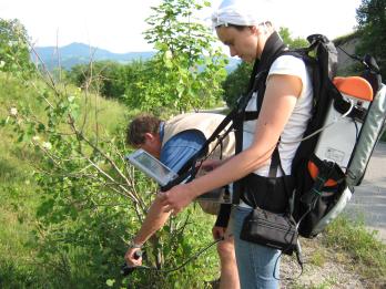
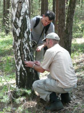
ImpactMin activities: The UAV mission was performed in the first week of August 2011 with subsequent field sampling in August-September. Vegetation was sampled within three 10 m bands along the stream Vormbäcken at three sampling sites downstream of the Kristineberg mining area. Species were determined in plots (50×50 cm) and their abundance was recorded on a 7-graded scale. The plots were randomly placed with a minimum distance of 2m between plots. Vegetation stands in the 50×50 cm plots are used for species determination of vegetation stands in the UAV images. In the analyses, we focus on the five most common species. Species composition and biomass in the vegetation plots will be related to the water chemistry in the stream Vormbäcken. We also initiated to accomplish the time series of land cover changes at the Kristineberg mining area by manually digitizing orthophotographs 1954 - 2010 with ca 10-yrs time interval.
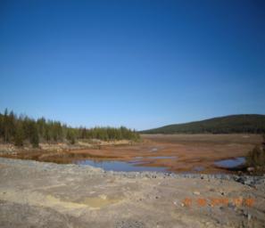
Kristineberg on-site image (Photo by LTU)
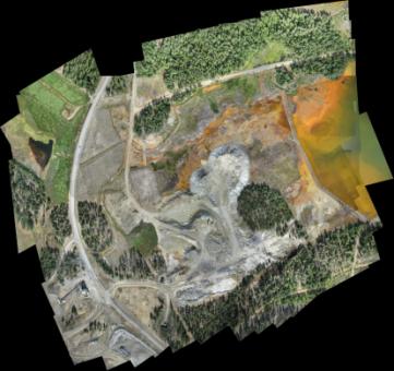
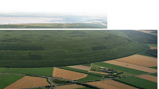
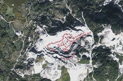
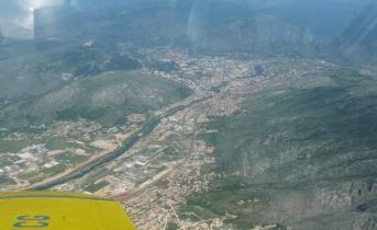
UAS mosaic image, Kristineberg (Smartplanes - LTU)
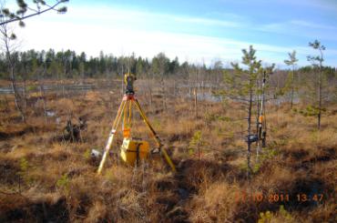
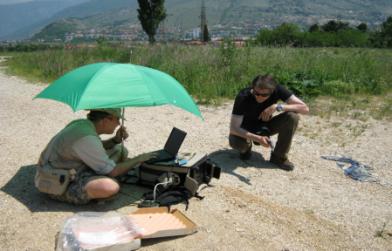
Field sampling location, Kristineberg (Photo by LTU)
If you wish to locate the demonstration site in Google Earth, download and open this file:kristineberg.kml
Current situation: Five ponds are located along a valley between two mountain ridges. Initially, the tailings were deposited in two ponds; later, new ponds were constructed in the south of the confluence between Rävlidmyrbäcken and Vormbäcken.
At closure, the tailings area consisted of five individual ponds containing pyrite rich tailings, including three old drained ponds containing weathered tailings, one recently operated pond containing unweathered material, and one pond containing substantial quantities of precipitates from the treatment of acidic mine water.
ImpactMin activities: The UAV mission was performed in the first week of August 2011 with subsequent field sampling in August-September. Vegetation was sampled within three 10 m bands along the stream Vormbäcken at three sampling sites downstream of the Kristineberg mining area. Species were determined in plots (50×50 cm) and their abundance was recorded on a 7-graded scale. The plots were randomly placed with a minimum distance of 2m between plots. Vegetation stands in the 50×50 cm plots are used for species determination of vegetation stands in the UAV images. In the analyses, we focus on the five most common species. Species composition and biomass in the vegetation plots will be related to the water chemistry in the stream Vormbäcken. We also initiated to accomplish the time series of land cover changes at the Kristineberg mining area by manually digitizing orthophotographs 1954 - 2010 with ca 10-yrs time interval.
Kristineberg on-site image (Photo by LTU)
UAS mosaic image, Kristineberg (Smartplanes - LTU)
Field sampling location, Kristineberg (Photo by LTU)
Geography: Rosia Montana is a small village in the forested mountains of western Romania. The site of gold deposits is believed to be the largest in Europe. The Rosia Montana Project (RMP) is located near the village of Rosia Montana in west-central Romania, approximately 50 km northwest of the regional capital, Alba Iulia, in the Metaliferi Mountains, which belong to a larger, regional mountain unit called the Apuseni Mountains of Transylvania.
If you wish to locate the demonstration site in Google Earth, download and open this file:rosia.kml
Current situation: The Rosia Montana region represents a complex geological-mining environmental interaction area, exhibiting over two millennia of surface and underground mining and milling operations. Mountainous, vegetated and water-saturated setting of the area gives additional complexity in characterizing the area from the environmental standpoint. Due to recent developments and planned mining operations, Rosia Montana is expected to be the largest open-cast gold mine in Europe.
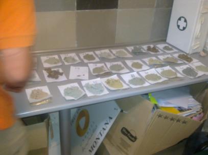
ImpactMin activities: The level of gamma radiation in the mining area was measured by using an ORTEC digiBASE high performance digital gamma spectrometer. The determined gamma dose was generally in the normal range for Europe. Some slight increases were detected in some spots, however very close to the European threshold. A large series of soil, rocks and sediments samples were collected from the waste dumps, open pits, future open pit areas, and unaltered country rocks. Additionally, chemical iron-aluminium precipitates from streams and acid seepages were collected. Ground infrared spectroscopy was performed by using an ASD spectroradiometer. Selected samples were submitted to mineralogical and chemical analyses. A complex on-site vegetation spectral survey was started-up in order to assess the response of plants to the stress induced by acid soil/water and heavy metals. The mineralised areas are showing vegetation anomalies, mainly expressed by a strong decrease in biodiversity.
Field spectroscopy, Rosia Montana (Photo by UBB)
WorldView2 image with sampling locations, Rosia Montana (by Geosense)
Rock and soil samples, Rosia Montana (Photo by Geonardo)
If you wish to locate the demonstration site in Google Earth, download and open this file:rosia.kml
Current situation: The Rosia Montana region represents a complex geological-mining environmental interaction area, exhibiting over two millennia of surface and underground mining and milling operations. Mountainous, vegetated and water-saturated setting of the area gives additional complexity in characterizing the area from the environmental standpoint. Due to recent developments and planned mining operations, Rosia Montana is expected to be the largest open-cast gold mine in Europe.
ImpactMin activities: The level of gamma radiation in the mining area was measured by using an ORTEC digiBASE high performance digital gamma spectrometer. The determined gamma dose was generally in the normal range for Europe. Some slight increases were detected in some spots, however very close to the European threshold. A large series of soil, rocks and sediments samples were collected from the waste dumps, open pits, future open pit areas, and unaltered country rocks. Additionally, chemical iron-aluminium precipitates from streams and acid seepages were collected. Ground infrared spectroscopy was performed by using an ASD spectroradiometer. Selected samples were submitted to mineralogical and chemical analyses. A complex on-site vegetation spectral survey was started-up in order to assess the response of plants to the stress induced by acid soil/water and heavy metals. The mineralised areas are showing vegetation anomalies, mainly expressed by a strong decrease in biodiversity.
Field spectroscopy, Rosia Montana (Photo by UBB)
WorldView2 image with sampling locations, Rosia Montana (by Geosense)
Rock and soil samples, Rosia Montana (Photo by Geonardo)
Geography: The city of Mostar, located in the southern portion of Bosnia and Herzegovina (BiH), was one of the main areas of aluminium extraction, fabrication and aircraft industries. Mostar is situated on the river Neretva and is the fifth-largest city in the country. Three demonstration sites are proposed for investigation. The first is on the northern part of the city, which is a red mud disposal site. The second one is an abandoned coal mine near the city center, and the third one is in the south of the city and is a planned lignite mine.
If you wish to locate the demonstration site in Google Earth, download and open this file:mostar.kml
Current situation: The second site is an ongoing rehabilitation project in the former coal mine Vihovici, a site of great threat to the local population and the environment due to toxic gas emissions, landslides and volatile organic compounds (VOCs) into the water supply.
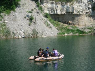
ImpactMin activities: During April-June 2011, the Vihovici mine site, various sites within city of Mostar and Neretva river have all been extensively appraised with water and spectroscopic sampling programs to support the planned airborne hyperspectral survey. Personnel from the Faculty of Civil Engineering in Mostar, Photon and Geosense have spent several days in the field selecting sites for calibration of airborne data as well as test-sites for water quality measurements. The site appraisal was augmented with two ASD spectrometers, small UAV and ultimately high-resolution airborne hyperspectral data on May 19, 2011.
The analysis of hyperspectral data shows several sites of interest where iron oxide/hydroxide and possibly sulfate minerals occur, which may be related to accumulations of mine-waste as well as household waste materials which could negatively impact the water quality. Several areas of vegetation stress have also been noted in the area. The results from water sampling data suggest that the majority of sampled waters are relatively clean, but that the polluting elements may be contained in the sediment. The research continues with additional sampling and planned gamma-ray data acquisition.
Water sampling, Vihovici (Photo by GFMO)
Aerial data acquisition, Mostar view (Photo by Photon)
Calibration site, Vihovici (Photo by Photon)
If you wish to locate the demonstration site in Google Earth, download and open this file:mostar.kml
Current situation: The second site is an ongoing rehabilitation project in the former coal mine Vihovici, a site of great threat to the local population and the environment due to toxic gas emissions, landslides and volatile organic compounds (VOCs) into the water supply.
ImpactMin activities: During April-June 2011, the Vihovici mine site, various sites within city of Mostar and Neretva river have all been extensively appraised with water and spectroscopic sampling programs to support the planned airborne hyperspectral survey. Personnel from the Faculty of Civil Engineering in Mostar, Photon and Geosense have spent several days in the field selecting sites for calibration of airborne data as well as test-sites for water quality measurements. The site appraisal was augmented with two ASD spectrometers, small UAV and ultimately high-resolution airborne hyperspectral data on May 19, 2011.
The analysis of hyperspectral data shows several sites of interest where iron oxide/hydroxide and possibly sulfate minerals occur, which may be related to accumulations of mine-waste as well as household waste materials which could negatively impact the water quality. Several areas of vegetation stress have also been noted in the area. The results from water sampling data suggest that the majority of sampled waters are relatively clean, but that the polluting elements may be contained in the sediment. The research continues with additional sampling and planned gamma-ray data acquisition.
Water sampling, Vihovici (Photo by GFMO)
Aerial data acquisition, Mostar view (Photo by Photon)
Calibration site, Vihovici (Photo by Photon)
Geography: The Ural, in geological and geographical meaning, is a fragment of Paleozoic fold area expressed as a mountain chain and has a width of 150 to 300-400 km and a length of about 2,000 km. South Ural Mountains of Russia (700 km) contain mainly massive sulphide deposits. It has a continental climate, with extremes of temperature, and lies within the South Taiga and forest-steppe zones.
If you wish to locate the demonstration site in Google Earth, download and open this file:russia.kml
Current situation: Today, many of the mineral deposits are exhausted or are uneconomic in current world markets. The extraction technologies used in most operations are inefficient and environmentally unsound. In certain areas, pollution from past and current mining-related activities is known to be heavily impacting on human and environmental health. From a political and sociological perspective, large-scale closure of operations is currently impossible as mining industries are major employers, which underpin the economy of the region.
ImpactMin will address the situation in the following areas:
These samples are in the process of being analysed at IMIN, GEOS and UNEXE. The results of these studies will be used to ground-truth and augment remote sensing studies to assess the impacts on sensitive ecosystems of atmospheric emissions (mainly SO2 and particulates containing potentially toxic metals) from the smelter and acid mine waters and wastes from mining-related activities. The results will also be compared with those from similar studies carried out 10 years ago as part of the MinUrals contract, to assess the effectiveness of new 'Ausmelt' emissions control technologies installed at the Karabash smelter in 2007.
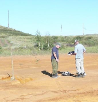
Field sampling, Mednogorsk (Photo by Geosense)
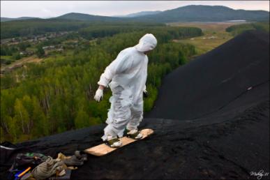
Waste dump, Karabash (Photo from Panormaio)
Lichen sampling site, field check Karabash (Photo by Geosense)
If you wish to locate the demonstration site in Google Earth, download and open this file:russia.kml
Current situation: Today, many of the mineral deposits are exhausted or are uneconomic in current world markets. The extraction technologies used in most operations are inefficient and environmentally unsound. In certain areas, pollution from past and current mining-related activities is known to be heavily impacting on human and environmental health. From a political and sociological perspective, large-scale closure of operations is currently impossible as mining industries are major employers, which underpin the economy of the region.
ImpactMin will address the situation in the following areas:
- Karabash, located in the South Taiga vegetative zone of the Chelyabinsk district of Russia, is host to a large copper smelter and several abandoned mine workings, tailings dams, waste dumps and stockpiles of concentrates. In 1995, the Russian Ministry of the Environment and Ecology designated the town as an ecological disaster zone.
- Mednogorsk, located in "steppe mountain" zone, is host to a large copper smelter and several abandoned mine workings (with two open pits with pit lakes' water depth of 39-45 m), tailings dams, waste dumps and stockpiles of concentrates.
These samples are in the process of being analysed at IMIN, GEOS and UNEXE. The results of these studies will be used to ground-truth and augment remote sensing studies to assess the impacts on sensitive ecosystems of atmospheric emissions (mainly SO2 and particulates containing potentially toxic metals) from the smelter and acid mine waters and wastes from mining-related activities. The results will also be compared with those from similar studies carried out 10 years ago as part of the MinUrals contract, to assess the effectiveness of new 'Ausmelt' emissions control technologies installed at the Karabash smelter in 2007.
Field sampling, Mednogorsk (Photo by Geosense)
Waste dump, Karabash (Photo from Panormaio)
Lichen sampling site, field check Karabash (Photo by Geosense)